
Unverified
Sat imageries (before/after) of the destruction in Dulag, Leyte
18:11 Nov 16 2013 Bantayan Island, Philippines
Description
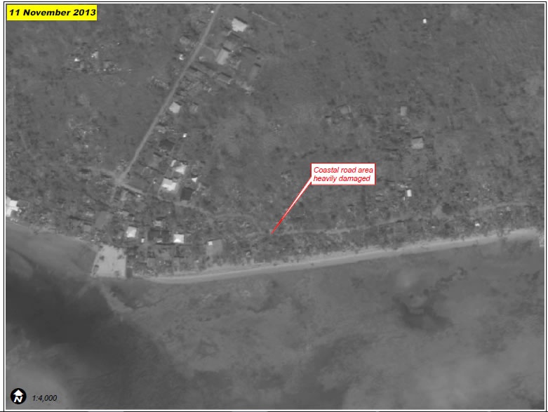
A portion of Sulangan municipality almost completely eradicated by Typhoon Haiyan. See Figure 1 (next page) for pre-disaster comparison.The southern end of Sulangan municipality with multiple structures and tree cover visibly intact in pre-crisis image (top) collected prior to Typhoon Haiyan. As of 11 November 2013 (bottom) many structures are missing near the coastal road with proximate debris indicative of complete destruction, and areas of tree cover are likewise destroyed.
UNOSAT - NOV 11
News Source Link
https://philippines.humanitarianresponse.info/sites/philippines.humanitarianresponse.info/files/UNOSAT_TC20131108PHL_Sulangan_A4_Report_v1.pdfhttps://philippines.humanitarianresponse.info/typhoon-haiyan-yolanda-maps-and-visuals
| Credibility: |  |
 |
0 |
Additional Reports
Vidéo : First look at Bantayan Island after 'Yolanda' devastation
01:26 Nov 11, 2013
Bantayan Island, Philippines, 5.83 Kms
1 aerial photo of Houses destroyed at Bantayan island
04:37 Nov 11, 2013
Bantayan Island, Philippines, 5.83 Kms
1 photo of The Ramon Aboitiz Foundation Inc. (RAFI) distributed 3,000 relief packs in the towns of Bantayan, Sta. Fe and Madridejos in Bantayan Island last Sunday
01:21 Nov 15, 2013
Santa Fe, Bantayan, Madridejos, Bantayan Island, Philippines, 6.84 Kms
3 aerial photos of destructions at Bantayan Islands
18:36 Nov 12, 2013
Bantayan Island, Philippines, 7.38 Kms
Leave a Comment